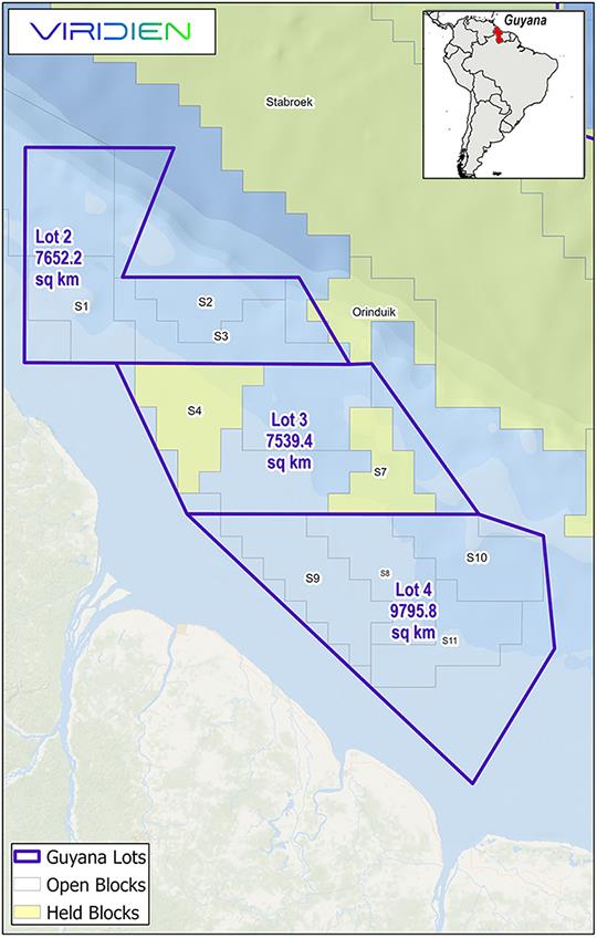
Viridien and BGP have entered into an agreement with the Ministry of Natural Resources of the Cooperative Republic of Guyana to launch a massive multi-client 3D seismic acquisition and imaging program across the shallow water acreage lots 2, 3 and 4, an area comprising approximately 25,000 sq kms.
New data will be acquired by BGP and high-end seismic imaging will be performed by Viridien, applying its industry-leading proprietary advanced workflows, including state-of-art shallow water demultiple and time-lag full-waveform inversion (TLFWI). The resulting new subsurface images, along with any potential future reimaging of existing seismic data, will help unlock the hydrocarbon potential of the shallow water portion of the basin and support Guyana’s future licensing round in the area.
Joe Zhou, SVP, Americas, Earth Data, Viridien, said: 'Viridien has worked closely with the government of Guyana for over 15 years, acquiring, imaging and enhancing the country’s seismic data. Together with our partner BGP, we are delighted to have this new opportunity to provide the high-quality data necessary for operators to make confident, data-driven decisions, and ultimately unlock the hydrocarbon potential of a largely unexplored part of the basin in Guyana.'
Source: Viridien