
88 Energy has announced the results of its internal Prospective Resource assessment across its consolidated South Prudhoe acreage on Alaska's North Slope (100% working interest, 16.7% royalty).
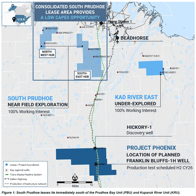
The South Prudhoe lease position covers approximately 52,269 acres within one of the most prolific hydrocarbon fairways on the North Slope, immediately south of the Prudhoe Bay Unit and Kuparuk River Unit. This acreage incorporates newly secured leases together with the former Project Leonis area, consolidating a highly strategic corridor of stacked reservoirs with direct access to existing infrastructure.
Highlights
- The update confirms material multi-million-barrel potential across multiple mapped prospects within five independent reservoir intervals, including maiden estimates for the Ivishak and Kuparuk reservoirs.
- All prospects are covered by modern 3D seismic data.
- The combined internal Prospective Resource estimate Gross (2U) Best Estimate of 507 million barrels (MMbbls) of oil and natural gas liquids (NGLs) (422 MMbbls net)[1] [2]
- Additional Brookian Resource upside expected to be defined within the North-West Hub, with multiple targets identified on the newly purchased Schrader Bluff 3D seismic data.
- Farm-out discussions and well planning underway targeting the multi-zone Augusta Prospect, which is adjacent to the Hemi Springs State-1 discovery well.
- Resources estimated for the N-W and S-E hubs support satellite development potential through existing third-party infrastructure.
|
South Prudhoe Total |
Hub |
Reservoir 2 |
Unrisked Prospective Oil and NGLs Resources (MMbbls) 1 2 |
|||||||
|
Probabilistic Method |
|
|
Low (1U) |
Best (2U) |
High (3U) |
MEAN |
GCOS |
|
||
|
Augusta |
N-W |
Iv, Kup |
45.2 |
64.4 |
91.3 |
66.7 |
48% |
|
||
|
Augusta North Cluster |
N-W |
Iv, Kup |
16.4 |
23.1 |
32.4 |
23.9 |
62% |
|
||
|
Lasso |
N-W |
Iv, Kup |
7.8 |
11.0 |
15.2 |
11.3 |
39% |
|
||
|
Greater Spurr Cluster |
S-E |
Iv |
11.5 |
23.6 |
49.9 |
28.0 |
43% |
|
||
|
Eaglecrest |
S-E |
Iv, SB |
4.9 |
9.1 |
17.2 |
10.3 |
47% |
|
||
|
Donoho O and N sands |
S-E |
SB |
68.4 |
160.7 |
370.2 |
196.8 |
22% |
|
||
|
Tressler |
S-E |
SB |
44.9 |
106.0 |
251.2 |
132.2 |
23% |
|
||
|
Hunter |
S-E |
SB |
6.4 |
17.4 |
45.8 |
22.8 |
24% |
|
||
|
Cooper Canyon |
S-E |
SB |
39.6 |
91.3 |
211.3 |
112.6 |
26% |
|
||
|
Total (100% Gross) |
|
|
245.1 |
506.6 |
1,084.5 |
604.6 |
|
|
||
|
Total (83.33% Net Entitlement) |
204.2 |
422.2 |
903.7 |
503.8 |
|
|
||||
Managing Director, Ashley Gilbert, commented:
'This updated internal Prospective Resource assessment highlights the significant scale and quality of our South Prudhoe acreage position, with material multi-million-barrel potential now defined across seventeen mapped prospects and five independent reservoir intervals. We can now clearly see a multi-zone, multi-million-barrel opportunity with additional potential growth to come.
The Ivishak and Kuparuk prospects are positioned immediately adjacent to two of North America's largest oil fields which have been producing since 1977. This creates low-risk potential for a fast-track and low-cost development upon success through existing, third-party infrastructure.
Importantly, we see further upside ahead. The refined Brookian Formation update, incorporating the Canning and Schrader Bluff reservoirs, is just the beginning with additional upside in our North-West Hub area expected from within the West Sak and Price Creek reservoirs.
Our focus is now firmly on upgrading these current resource estimates while at the same time advancing farm-out discussions and well planning to unlock the full value of this exciting asset.'
South Prudhoe Overview
Unlocking Low-Risk Barrels in a World-Class Petroleum System
88 Energy's South Prudhoe acreage lies immediately south of the giant Prudhoe Bay and Kuparuk River Units, representing two of North America's largest and most productive oil fields. This strategic position directly overlies a proven petroleum system anchored by the Ivishak and Kuparuk reservoirs, with additional upside expected to be delineated within the Brookian sequence.
Mapping of historical Storms and Schrader Bluff 3D seismic data, integrated with petrophysical analysis and offset well data, has confirmed multiple fault-block closures. Oil shows, flow tests and production in offset wells such as Hemi Springs State-1 and PBU P-27 demonstrate commercial reservoir properties and strong charge potential.
This combination of proven deep conventional reservoirs and shallower plays provides stacked-pay potential with near-term drilling objectives and long-term growth upside.
Click here for full announcement
Source: 88 Energy