
John Donato (retired ex-Merlin employee) continues to work with the Beneath Britain/UKOGL (UK Onshore Geophysical Library) Group. In conjunction with Chris Pullan, he has recently published a paper discussing the deep geology of the area on, around and under (!) the Derbyshire Dome. A copy of their paper ‘The Bakewell Granite, a postulated granite intrusion located beneath the eastern flank of the Derbyshire Dome, Northern England, UK’ can be downloaded from the UKOGL site.
Surface geology shows the Derbyshire Dome to expose a stable core of Lower Carboniferous limestones, surrounded by outward-dipping belts of Namurian sandstones and shales and an outer fringe of Westphalian Coal Measures. Beneath the surface, the Dome was thought to hide a large, buried granite body beneath its high limestone plateau. Early geologists liked the idea: a buoyant granite could have elevated the land and supplied the heat that helped form Derbyshire’s well-known mineralised zones.
But mid-twentieth-century drilling suggested a different story. Boreholes at Woo Dale (1947), Eyam (1970) and Caldon Low (1977) penetrated through the limestones and encountered Devonian and Ordovician sandstones, shales and volcanic rocks – not a buried granite. Seismic refraction surveys mapped deep faults and hinted at a strange, thick low-density layer, but this evidence wasn’t pursued at the time. Consequently, by the 1980s, the buried granite theory had been forgotten.
Now the clock is turning back. Modern seismic reflection interpretation together with associated gravity stripping has revealed a smooth, elliptical residual gravity low beneath the central and eastern parts of the Dome. Donato and Pullan interpret this low as a buried granite, now named the Bakewell Granite. The granite is buried beneath the Devonian and Ordovician sediments penetrated in the wells and approximately matches the depth and thickness of the low-density layer previously identified.
After decades in the shadows, the granite is back, not as an old geological myth, but as a renewed and compelling possibility as rediscovered by modern geophysical interpretations.
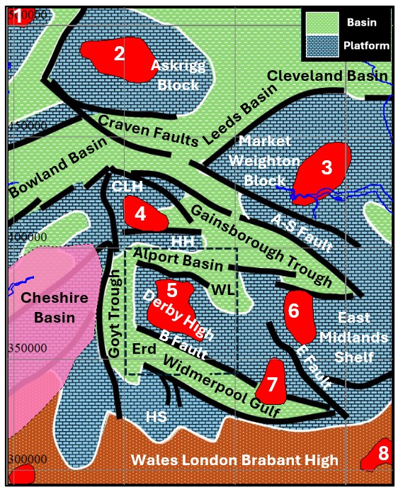
Figure 1 – Extracted from the paper showing Early Carboniferous paleogeography with major syn-rift faulting and postulated granite intrusions including the newly proposed Bakewell Granite (5). The intrusions are shown with red shading and are numbered as follows:- 1-Lake District, 2-Wensleydale, 3-Market Weighton, 4-Holme, 5-Bakewell, 6-Newark, 7-Bingham and 8-Wash. Carboniferous paleogeography is uncertain beneath the thick Permo-Triassic sediments of the Cheshire Basin, shown as pink. Abbreviated nomenclature is as follows:- CLH-Central Lancashire High, A-S Fault-Askern-Spittal Fault, HH-Holme High, WL-Welbeck Low, B Fault-Bonsall Fault, E Fault-Eakring Fault, HS-Hathern Shelf and Erd-Area of inverted and eroded Widmerpool Gulf. The early Carboniferous paleogeography is derived, with minor modification, from various sources including Fraser and Gawthorpe (1990), Corfield et al. (1996), Andrews (2013) and Fraser et al. (2024).
Source: Merlin Energy Resources